


Tó Niłtólí members say 3,720-foot contour line was intended to keep Diné from Lake Powell
Navajo Times | Krista Allen
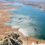
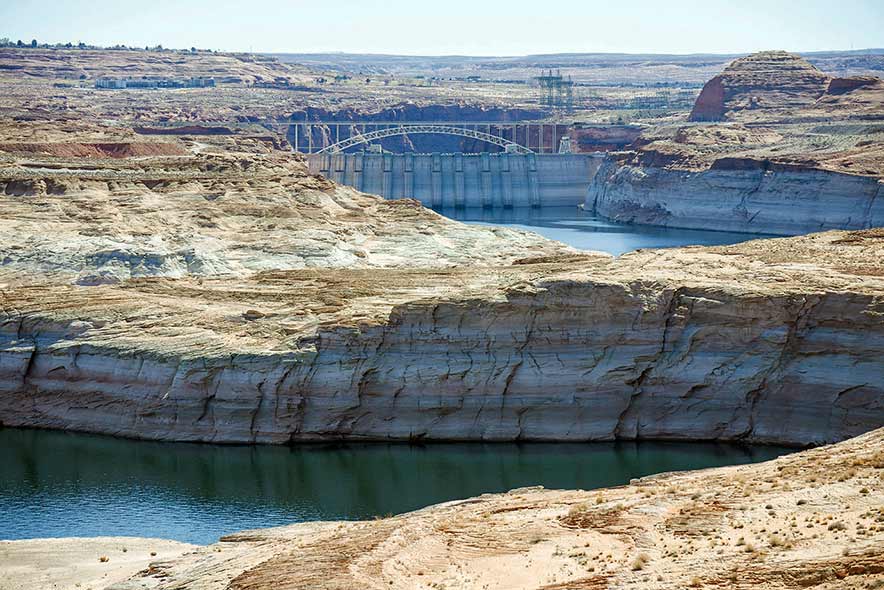
The Glen Canyon Dam, Dá’deestł’in Hótsaa, marks where the water level in Lake Powell on the Colorado River, reaches. The water level decline brought the reservoir level to a historic low this year.
DÁ’DEESTŁ’IN HÓTSAA
The Naabik’íyáti Tó Niłtólí Task Force members say the elevation of Lake Powell will never reach the 3,720-foot level reserved for Navajo Nation control.
According to the Bureau of Reclamation, the Glen Canyon Dam crest elevation is 3,715 feet and the top of the spillway – or full pool – is 3,700.5 feet.
“So, it (water) will never reach 3,720 feet,” said Delegate Paul Begay Jr., the task force’s chair. “That’s how we (the tribe) were cheated.
“This is the only place in the world where the water is divided by elevation,” he said.
For more than six years, Navajo Nation officials and attorneys negotiated an agreement over land and water rights in the Colorado River.
3,720-foot contour line
The tribe, in late 1963, advanced a revised agreement and divulged what it wanted from the park service, such as Navajo concessions along the south shore of Lake Powell, according to history.
By 1966, shoreline development and facilities on Aztec Creek downstream from Tsé’naa Naní’áhí, Rainbow Bridge, were of concern to the tribe.
Park service and tribal officials tried negotiating a land swap that granted the park service access to the shore along Aztec Creek in exchange for tribal rights at Echo Camp south of Tsé’naa Naní’áhí.
Based on Public Law 85-868, better known as the 1958 Navajo-U.S. Land Exchange Act, all lands above 3,720 feet could be developed only by the park service with the tribe’s approval.
The park service determined that the water level at the mouth of Aztec Creek lay below the stipulated elevation requirements.
To show the park service its seriousness, the tribe issued a business permit to the late Harold Drake Sr. from Naatsis’áán. It allowed him to develop concessions at Echo Camp before an agreement was completed.
The tribe also solicited development support from Standard Oil Co. to help build facilities at Padre Point.
Because of these events, the tribe set a meeting with the park service and the BIA to work out the agreement details and a proposed land expansion at Navajo National Monument in Betatakin, Arizona. The meeting happened in Tsébigháhoodzání on Jan. 26, 1966.
Based on the stipulations of the 1958 Act, the tribe believed that the park service was trespassing on tribal lands at Aztec Creek because the agency didn’t solicit tribal approval to construct floating docks.
Between 1966 and 1967, park relations with the tribe declined as the elections at that time didn’t help the matter, and numerous attempts to solidify an agreement were met with tribal charges of deception and fraud.
The park service also began to reconsider its need to add any land to Tsé’naa Naní’áhí and affirming for tribal approval of public access through Aztec Creek’s floating facilities.
Park service and tribal officials and attorneys discussed another draft of the agreement during a third meeting. Then Chairman Raymond Nakai wrote to the park service’s Southwest Regional Director Daniel Beard requesting the agency’s assistance in helping the tribe generate a development plan for the tribe’s shoreline interests at the reservoir.
Beard responded enthusiastically, and cooperation with the tribe continued, according to history.
In another meeting in April 1969, then Regional Director Frank Kowski, Nakai, and William McPherson, the tribe’s attorney, argued that the tribe should be guaranteed the prospect of assuming control of all operations at the Aztec Creek floating facilities.
Kowski told Nakai and McPherson that Navajo control of the floating facilities was not an option and non-negotiable. He also said that the park service would move the floating facilities to another location and end negotiations for an agreement.
Because the tribe was facing financial difficulties, it increased the tribe’s commitment to the agreement and the tourism revenues it could ensure and met every month in 1969.
On Dec. 2, the Council passed a resolution authorizing Nakai to negotiate and complete a final agreement. The details of the agreement were finalized the following year.
To set the ball rolling, then Interior Secretary Walter Hickel on Sept. 11, 1970, signed the quadrilateral agreement between the National Park Service, the Bureau of Indian Affairs, the Bureau of Reclamation, and the Navajo Nation.
Floyd Stevens, a task force member from Béésh Haagééd, said lands below and above the 3,720-foot contour line were negotiated in the agreement, which recognized Navajo preference rights to operate concessions on “Parcel B” lands. And any development plans for Parcel B lands above 3,720 feet remained with the Nation.
Parcel B lands
Stevens said that the agreement expired on Sept. 10, 2020. The tribe last year extended the termination date to Sept. 10, 2021.
“It was 50 years of agreement,” Begay said. “It didn’t serve the Navajos. Back then (during the fifties and sixties), our people were cheated.
“Parcel B, from Łichíi’ii toward K’ai’bii’tó, Ts’ahbiikin, Ooljéé’tó, to Mexican Hat, is a circular area,” he said. “Glen Canyon National Recreation Area officials said Parcel B is now under park service’s jurisdiction.
“But we’ve been here for hundreds of years!” he said. “Today, we’re not Parcel B’s proprietors and can’t build anything in Parcel B without the park service’s agreement.”
“Right now, we refer to it as the ‘former quadrilateral agreement,’” Stevens explained. “That’s the proper term for it.
“We’re (task force) is trying to receive input from the local (Western) chapters,” he said. “The quadrilateral agreement should have been equally fair to all the parties. The BIA hasn’t been involved in anything around here regarding the water and land, and we have not met with them.”
Stevens said the 3,720-foot contour line was intended to keep Diné from using the reservoir and creating recreation and development.
Begay said the former quadrilateral agreement stated that the Nation and the park service would work together, but that stopped.
“We want to expunge that agreement and redo the entire agreement and include the Nation,” Begay said. “We want to quash Parcel B and have it returned to the Nation.
“We’d like to develop on it, herd our sheep on the land again, plant food, and conduct ceremonies,” he said.
To further the former quadrilateral agreement, the National Park Service, BIA, BOR and the Navajo Nation agreed to implement the development concept plan for Antelope Point Marina, a Navajo project, in 1994.
The Sept. 16, 1994, agreement also expired last September. The former quadrilateral, the 1994, and the 2003 bridge agreements governed the co-management of the Glen Canyon NRA, which includes Antelope Point and Tsé’naa Naní’áhí areas.
Glen Canyon NRA Superintendent William Shott, who’s been promoted to deputy regional director for Interior Region 8, 9, 10, and 12, did not respond to an email seeking comment and requesting and interview.

 Highway 264,
 I-40, WB @ Winslow