


Lake Powell near historic lows
Special to the Times | Krista Allen
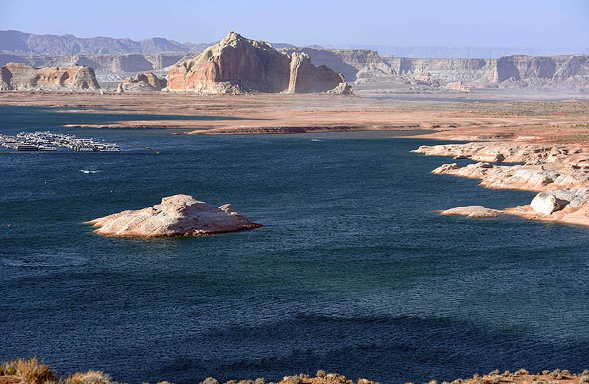
A view of Castle Rock at Wahweap Bay on Lake Powell shows dry soil conditions. A sobering forecast released by the Bureau of Reclamation shows Lake Powell dipping near historic low levels.
By Krista Allen
Special to the Times
DÁ’DEESTŁ’IN HÓTSAA
The water in the man-made Lake Powell reservoir near Western Navajo is approaching historic low levels following 20 years of drought in the Colorado River Basin.
Water levels at Lake Powell, the second-largest reservoir in the country, fell to 3,559.95 feet above sea level on Monday, down from an average of 3,604.09 at this time (May 26) last year, according to the Lake Powell Water Database.
Lake Powell is at 34.2% of full pool (24,322,000 acre-feet) and 140.8 feet below full pool (3,700) as of Wednesday morning.
The primary factors influencing Lake Powell – as well as Lake Mead, the largest reservoir in the country – are inflows into Lake Powell, according to the Bureau of Reclamation.
Upper Basin hydrology accounts for about 92% of the total streamflow in the basin. Inflow into Lake Powell is also affected by Upper Basin water use and the operation of reservoirs above Lake Powell.
Reclamation last month released 24-month projections forecasting that less Colorado River water will cascade down from the Rockies through Lake Powell and Lake Mead, and into the deserts of the Southwest and the Gulf of California.
Special to the Times | Krista Allen
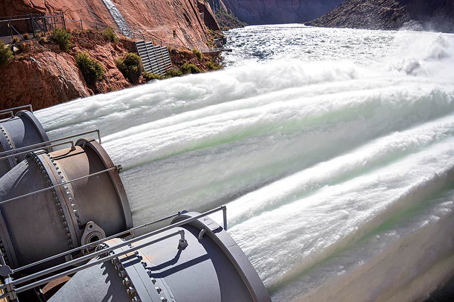
Lake Powell, better known as a disturbance flow, is released through the Glen Canyon Dam in Page, Ariz. Disturbance flows are periodically conducted and they are designed to simulate a spring-time runoff event, disturbing river bottom habitats.
The Colorado River, Tooh Bikooh Dinék’ehjígo, originates on the Colorado western slope. Over 25 significant tributaries join it. The Green River in Utah is the largest by both length and discharge.
Tooh Bikooh flows to the Gulf of California. It provides water to nearly 40 million people for municipal use, to irrigate nearly 5.5 million acres of land, and is the lifeblood for at least 22 federally recognized tribes, seven national wildlife refuges, four national recreation areas, and 11 national parks, according to Reclamation.
In August 2020, a 24-month study projected the Jan. 1, 2021, Lake Powell elevation below the 2021 Equalization Elevation of 3,659 feet and above 3,575 feet. The lake level was 3,582.06 feet that day, according to the Lake Powell Water Database.
With an 8.23-million-acre-foot release from Lake Powell in the water year 2021, an April 2021 24-month study projects the end-of-water-year elevation here below 3,575 feet. Lake Powell will continue to release 8.23 million acre-feet through the remainder of the water year.
The Bureau of Reclamation will release its subsequent major study in August.
Glen Canyon National Recreation Area officials advise visitors to be aware of changes to water access points and boat launch areas on the lake because of declining water levels. And water levels will continue to drop, according to Reclamation.
“The region and Coconino County is dependent on (the Colorado River),” said Coconino County District 5 Supervisor Lena Fowler. “Tours in Antelope Canyon are closed. Businesses won’t do so well (after Navajo parks reopen). It attacks jobs. It impacts all facets of the economy.”
Lena said water levels in Lake Powell are low, which means some visitors cannot launch their watercraft, and fewer visitors are coming to the area.
“These are tourists that are coming to the region,” Fowler added. “They come, maybe stay overnight, and they spend their dollars – and there are jobs (for the locals of Page-Lake Powell and Western Navajo).
“But if people are not able to come,” she said, “that means there are fewer jobs. So, it impacts all facets of our economy.”
“It is very concerning for the long term,” said President Jonathan Nez. “The Southwest has been in severe drought for years. The (coronavirus) pandemic magnified the importance of having clean water resources of families and communities.”
Nez said his administration is currently looking at ways to tap into water resources even more and conserve more water for future needs even though the water issue does not pose an immediate problem for Diné communities.
The threat of Colorado River shortages is arguably the water issue of most immediate concern to Arizona’s river communities and those in the Central Arizona Project service area – for both its direct impact on water users and its indirect effect on groundwater use, according to the Water Resources Research Center in Tucson.
As the water level of Lake Mead drops, shortages would be declared, triggering curtailment of water deliveries to Arizona by specified amounts.
The current water level at Mead is 1,074.84, which is 154.16 feet below the full pool of 1,229 feet, as of Wednesday morning.
Arizona, Nevada, and Mexico are making contributions to Mead in a collaborative effort to maintain water levels and avoid severe shortage conditions at least through 2022.
But a first-ever official shortage declaration from the Department of the Interior is almost certain later this year.
Special to the Times | Krista Allen
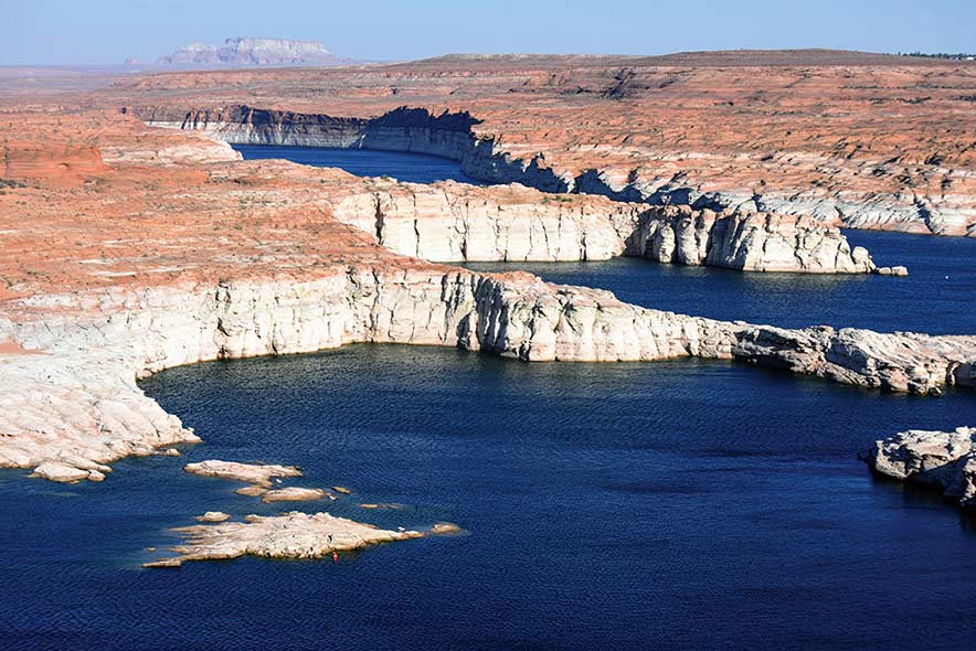
Southeast of Wahweap Marina is Antelope and Navajo canyons in Western Navajo. A white ring around canyons located at Lake Powell, the second-largest reservoir in the country, fell to 3,559.95 feet above sea level on May 24, down from an average of 3,604.09 at this time (May 26) last year. The ring shows decreased water levels over time.
The Interior secretary declares a shortage after they consult with water users in the Lower Basin states of California, Arizona, and Nevada, according to guidelines of a 2007 agreement among the seven states in the Colorado River Basin.
Because Tooh Bikooh is over-allocated – and because drought and climate change are likely to worsen as the region gets hotter and drier — the seven Colorado River Basin states in 2019 agreed on a plan to manage the river by voluntarily cutting their water use to prevent the federal government from imposing mandatory water restrictions on the supply.
As part of the Lower Basin’s drought contingency plan, the CAP would see its water supply cut by about one-third in 2022 because of its junior water rights in the river’s water. And farms in central Arizona would experience those water cuts.
Reclamation’s projections continue to show a very high likelihood of Tier 1 reductions in 2022 and in 2023, as well as an increased risk of Tier 2 conditions in the future, according to the CAP.
“We are prepared for these conditions,” reads a joint statement from the Arizona Department of Water Resources and CAP, “thanks in large part to Arizona’s unique collaborative efforts among water leaders, including tribes, cities, agriculture, industry and environmental organizations that developed innovative conservation and mitigation programs as part of the implementation of the drought contingency plan.”

 Highway 264,
 I-40, WB @ Winslow