


Oak Ridge Fire grows to 6,292 acres, zero containment, evacuations continue
Special to the Times | Donovan Quintero
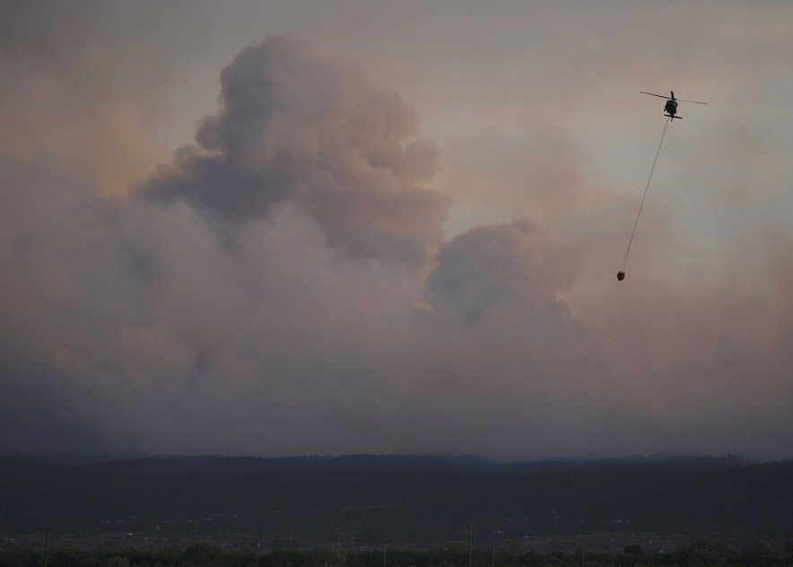
A firefighting helicopter carries a water bucket over the Oak Ridge Fire southwest of Window Rock on Sunday evening. Dense smoke and pyrocumulus clouds filled the sky as crews worked to slow the fast-moving blaze, which has burned 6,292 acres and forced some evacuations.
WINDOW ROCK
The Oak Ridge Fire has burned 6,292 acres southwest of Window Rock as of June 30 and remains at 0% containment, prompting continued evacuation orders and emergency response operations.
The wildfire, first reported June 28, is about 8 miles west-southwest of the Navajo Nation capital. It continues to threaten the communities of Hunters Point, Oak Springs and St. Michaels.
Smoke and active flame were visible late Sunday as the fire pushed through dense timber on the Defiance Plateau. By nightfall, a glow lit the sky as thick smoke spread over nearby homes, raising alarm about the fire’s rapid growth fueled by dry vegetation and shifting winds.
Special to the Times | Donovan Quintero
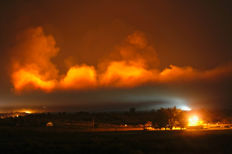
The Oak Ridge Fire burns intensely southwest of Window Rock on Sunday night, casting an orange glow across the horizon as smoke billows over nearby communities. Fire crews worked overnight to battle the fast-moving blaze, which has burned 6,292 acres and forced evacuations in Oak Springs and Hunters Point.
Families in the Hunters Point area began evacuating Saturday night, loading horses and sheep into trailers. By the time official orders were issued, more than 100 livestock had already been removed from homes and sheep camps threatened by the fire.
The Southwest Area Complex Incident Management Team 2, led by Incident Commander John Truett, assumed command early Monday. About 420 personnel are assigned to the fire, working day and night shifts. Additional crews and 10 engines have arrived, supported by helicopters, fixed-wing tankers, and drones.
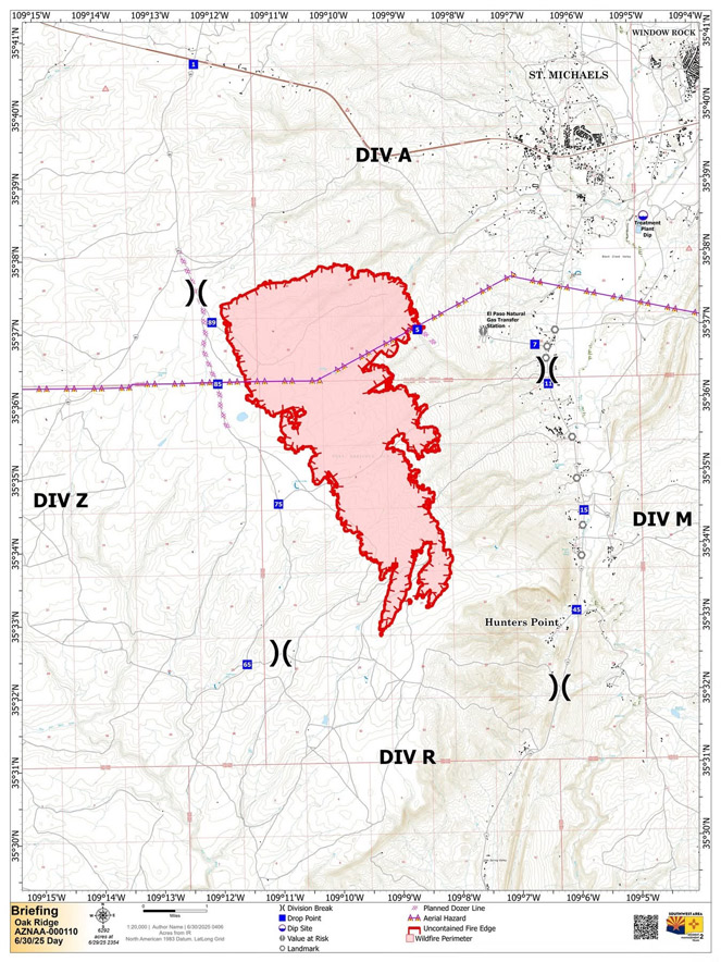
The fire is burning primarily south of Highway 264 and west of Navajo Route 12. A June 30 incident map shows the blaze expanding southward and westward across the plateau, near Hunters Point.
Courtesy
A fire operations map shows the Oak Ridge Fire perimeter southwest of Window Rock as of Monday morning. The wildfire, which has burned 6,292 acres, continues to push southeast toward Hunters Point, where mandatory evacuation orders remain in place. Fire crews are actively working in multiple divisions to contain the blaze.
Residents of Hunters Point and Oak Springs west of mile marker 12 on Navajo Route 12 to the El Paso Gas Station are under “Go” status and must evacuate immediately. In St. Michaels, homes along Roads 603, 604, and 605, as well as the Navajo Telecommunications Road, are also under “Go” status. Areas north of the gas station remain in “Set” status.
Shelters have been opened for evacuees at the Window Rock Fighting Scouts Event Center in Fort Defiance, and livestock is being accepted at the Dean C. Jackson Memorial Arena in St. Michaels.
Critical values at risk include homes in St. Michaels, pipeline infrastructure, and the Highway 12 corridor. Structure protection crews are working to hold fire lines established Sunday on the fire’s northern and eastern edges.
Fire behavior remains active and unpredictable. Winds are expected to shift from the northeast to the southeast later today, with gusts continuing into the night. Temperatures may climb into the 90s, and humidity could drop into single digits. Some overnight moisture may help increase humidity levels to 50–60% by Tuesday morning.
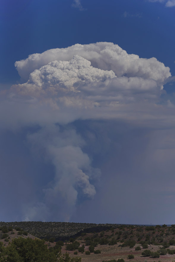
Special to the Times | Donovan Quintero
A towering pyrocumulus cloud forms above the Oak Ridge Fire southwest of Window Rock on Sunday. The wildfire has burned 6,292 acres, forcing evacuations in Oak Springs and Hunters Point as firefighters work to contain the fast-moving blaze. Pyrocumulus clouds develop from intense heat and rising smoke, signaling the fire’s extreme energy and rapid growth.
Officials warn that fire behavior can change rapidly because of wind and fuel conditions.
“The fire is wind-driven on receptive dry fuels and with today’s shifting winds the situation can change very quickly,” the incident update stated.
A Temporary Flight Restriction remains in place over the fire area. Drones are prohibited and could ground firefighting aircraft if spotted.
A public meeting will be held at 6 p.m. Monday at the Fighting Scouts Field House in Fort Defiance. The meeting will also be livestreamed on the BIA Wildland Fire Management – Navajo Region Facebook page.
Information: 928-465-7559 between 8 a.m. and 8 p.m.

 Highway 264,
 I-40, WB @ Winslow