


Wet weekend, winter storm warning in effect
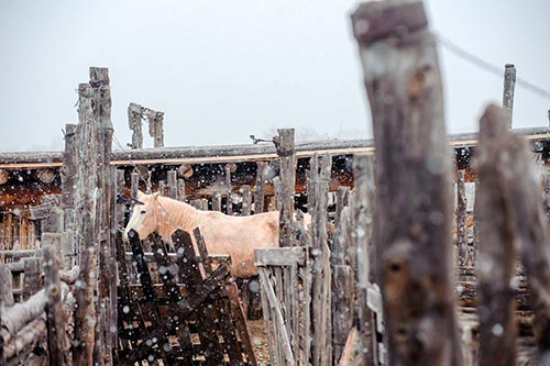
Navajo Times | Adron Gardner Snow falls on a horse at the stables of the Hubbell Trading Post in Ganado Thursday.
TS’AHBIIKIN, Ariz.
The National Weather Service has issued a winter storm warning for northern Arizona. And the wet weekend has already begun.
Navajo Times | Adron Gardner
Snow falls on a horse at the stables of the Hubbell Trading Post in Ganado Thursday.
“Indeed, we’ve a significant winter storm,” said Brian A. Klimowski, meteorologist in charge of the National Weather Service in Bellemont, Arizona. “And it’s going to impact northern Arizona starting Thursday (Jan. 19) and will continue through Monday (Jan. 23) with a couple of breaks in between.”
The winter storm warning was issued Wednesday, Jan. 18, for several areas, including the Coconino and Kaibab plateaus, northern Gila and Yavapai counties, Grand Canyon, eastern and western Mogollon Rim, White Mountain, and Oak Creek and Sycamore canyons.
Klimowski told the Navajo Times that the warning is in effect for most of northern Arizona above 5,500 feet that started Thursday morning (Jan. 19) and will extend through noon on Saturday, Jan. 21.
An extended period of snow has started above 5,500 feet with heavy snow accumulation by Saturday afternoon, said Klimowski. The snow level is going to fluctuate a bit between 4,800 and 5,500 feet.
“But in general, it’s above 5,500 feet that we’re looking for the greatest accumulation,” Klimowski said.
The storm will come in two punches.
The first one, which already started, will continue through tonight. And the second one, a much more significant storm will start later on Friday, Jan. 20 and continue into Saturday morning.
“The second storm … will have the greatest impact in most areas,” Klimowski said. “It’s going to have slightly slower snow levels and heavier precipitations.”
“So Friday night and early Saturday will be our focus for the greatest impact in northern Arizona,” he continued. “Keep in mind, these two storms.”
But that’s not all.
[alert color=”800000″]See National Weather Service forecasts now[/alert]
Another storm will hit on Monday. However, Klimowski says, Monday’s storm might come in earlier, as soon as late Sunday or even Sunday night.
Monday’s storm will also bring heavy snow to northern Arizona with lower snow levels, possibly down about 4,500 feet or so, said Klimowski. The NWS is keeping an eye on that one.
“We’re not going to be out of the woods until Tuesday,” he said. “So be prepared.”
For Flagstaff, the latest NWS map shows snowfall accumulation at 12 to 18 inches.
“For much of Mogollon Rim, it’s going to be all snow,” Klimowski said. “The first peak will be (this evening), probably before midnight.”
The high country is not going to see much of a break with a continuation of light snow and snow showers, and tailing off a bit. But it will really ramp up Saturday night and into Saturday morning.
“This is going to be a very intense time of snowfall and winds gusting to about 30 mph for Flagstaff and Forest Lake, Arizona,” Klimowski said. “Mogollon Rim is going to be impacted severely on Friday night and on Saturday morning.”
Klimowski says people should be prepared for these kinds of conditions, saying people should certainly anticipate significant and dangerous travel overnight on Friday and into Saturday.
“It’s going to sweep through with a lot of wind,” Klimowski said. “Snow levels will lower to about 5,500 feet.”
Coconino County announced yesterday that the county’s emergency management is working with public works, law enforcement agencies, the Arizona Department of Transportation, utility companies, among other entities to ensure a coordinated response for any adverse impact the storm may have on residents.
The American Red Cross also announced that chapters across Arizona are preparing for the series of storms by rallying volunteers and keeping in touch with local emergency management offices.
In Show Low, Arizona, residents will see peaks a bit later with the first peak of snow ramping up this evening and tonight, and hail on Friday. Residents will seek another peak late Friday night and into Saturday morning.
For the northeast part of Arizona – Black Mesa, Chuska Mountains, and Window Rock – residents will see less snow.
“They’re largely shadowed by the Mogollon Rim,” Klimowski said. “The trajectory of this storm in the northeast to the southeast largely keep them out of the heaviest snow area.”
In the fullness of time, Diné in Western Navajo will see a lot of muddy roads at or above the snow level, he added.
Coconino County District 5 Supervisor Lena Fowler said people in her district – Coppermine, Fredonia, Jacob Lake, Kaibeto, LeChee, Little Colorado River, Marble Canyon, Naatsis’áán, North Rim, Page, Ts’ahbiikin, and Tónaneesdizí – need to be very careful during travel and need to be prepared for this triple threat storm.
“Check on your families and see if they need firewood,” Fowler urged. “And put together a supply kit.”
To read the full article, pick up your copy of the Navajo Times at your nearest newsstand Thursday mornings!
Are you a digital subscriber? Read the most recent three weeks of stories by logging in to your online account.

 Highway 264,
 I-40, WB @ Winslow