
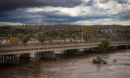






San Juan River forecast to flood again at Shiprock as heavy rain hits region

SHIPROCK
The San Juan River here is expected to rise above flood stage Monday evening as another round of heavy rain brought flooding and road damage Sunday to communities still recovering from October’s storms.
The National Weather Service in Albuquerque forecast a crest of 16.2 feet early Tuesday, exceeding the river’s 15.5-foot flood stage. The river measured 10.6 feet at noon Sunday and was expected to fall below flood stage Tuesday morning.
A river flood warning for Shiprock remains in effect from Monday evening through Tuesday evening.
At 1:27 p.m. Sunday, the weather service issued a separate flood warning for San Juan County through 11 a.m. Monday, covering communities including Shiprock, Farmington, Bloomfield, Kirtland and Ojo Amarillo.
Forecasters reported rising creeks, water flowing through arroyos and damaged roads. Additional flooding was expected as moderate rainfall continued.
Earlier Sunday, emergency managers reported that New Mexico Highway 170 had washed out between mile markers 3 and 18. The report appeared in a flash flood warning issued at 12:34 p.m. for north-central San Juan County, including Aztec, Flora Vista, Cedar Hill and La Plata.
That warning remained in effect until 8:30 p.m. Sunday, with another half-inch to an inch of rainfall possible.
In northeastern Arizona, the weather service in Flagstaff issued a flash flood warning at 10:27 a.m. for areas of Apache, Navajo, Coconino and Gila counties.
The warning, effective until 4:30 p.m. Sunday, included Dilkon, Ganado, Piñon, Leupp and Nazlini. Radar indicated that 0.75 to 1.5 inches of rain had fallen in the warned area, with flash flooding already occurring or expected to begin shortly.
San Juan County emergency managers warned that the San Juan, Animas and La Plata rivers could overflow their banks Sunday evening as additional rainfall reached waterways affected by the previous storm.
“Previously flooded areas will flood again and could flood additional areas,” according to the countys emergency alert.
Residents were advised to prepare emergency supplies, be ready to evacuate and avoid crossing running water. Shelter was available at McGee Park.
Flood warnings also covered the La Plata River below Redmesa and the Animas River near Cedar Hill and at Farmington, where forecasters expected minor flooding.
The La Plata River was projected to crest at 10.5 feet late Sunday, exceeding its 9-foot flood stage and approaching the 10.8-foot crest recorded in August 1934. Water levels were expected to fall below flood stage Monday afternoon.
Near Cedar Hill, the Animas River was forecast to reach 11.2 feet late Monday morning, above its 10.5-foot flood stage. The projected crest approached the 11.3-foot level recorded in September 1970.
At Farmington, the Animas was expected to reach 11.1 feet Monday afternoon, exceeding its 10-foot flood stage before receding early Tuesday.
A separate flood advisory remained in effect for the San Juan River at Farmington through Tuesday afternoon. The river was forecast to crest at 8.1 feet Monday afternoon, below its 8.5-foot flood stage.
The Weather Prediction Center placed parts of the Four Corners region under a moderate risk of excessive rainfall Sunday, Level 3 of 4.
Forecasters expected 3 to 5 inches of rain in portions of the Mogollon Rim, with heavy rainfall also threatening the San Juan Mountains and canyon areas of northern Arizona and southern Utah.
Ground saturated by October’s storms increased the likelihood of rapid runoff into rivers, washes and arroyos, adding to concerns about roads already damaged by flooding.
The Navajo Division of Transportation has been responding to major washouts and impassable routes under a plan coordinated through the Navajo Nation Emergency Operations Center, with priority given to emergency access and restoring damaged roads.
In Dennehotso, flooding caused additional damage to the Dennehotso Loop, comprising Navajo Routes 6460 and 6461, while it was under construction. The route was left impassable, making it difficult for some families to reach their homes and livestock.
The Navajo Division of Transportation has been responding to major washouts and impassable routes under a plan coordinated through the Navajo Nation Emergency Operations Center, with priority given to emergency access and restoring damaged roads.
Forecasters warned that rivers could continue rising after the rainfall ends, prolonging flooding and leaving riverbanks and damaged roads hazardous even as the storm moves out of the region.
Readers can support Navajo Times journalism with an e-Edition subscription, available through our Navajo Times Store.
 Highway 264,
 I-40, WB @ Winslow
