



Tornado watch issued as storms bring flooding, damage to northern Arizona

WINDOW ROCK
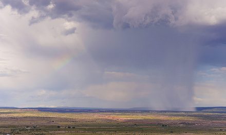
Large hail, damaging winds and possible tornadoes threatened northeastern Arizona on Thursday as flooding affected Navajo Nation communities and emergency crews responded to storm damage in Overgaard.
The National Weather Service issued a tornado watch Thursday morning for much of eastern Arizona and western New Mexico, including Apache, Coconino and Navajo counties. The watch was scheduled to expire at 8 p.m. Mountain Standard Time, or 9 p.m. Mountain Daylight Time on the Navajo Nation.
Forecasters warned that rotating thunderstorms, known as supercells, could produce hail 1 to 2 inches in diameter, wind gusts exceeding 60 mph and a few tornadoes. The greatest threat was expected in eastern Arizona, with severe-weather conditions gradually declining from west to east through the afternoon and evening.
The weather service’s Flagstaff office identified Chinle, Fort Defiance, Kayenta, Lukachukai and Window Rock among the communities under the watch. Other areas included Flagstaff, Holbrook, Show Low, Snowflake, Springerville, St. Johns, Whiteriver and Winslow.
A strong Pacific weather system brought widespread showers and thunderstorms to northern Arizona, adding to flooding concerns in areas already saturated by rainfall.
The weather service issued flood warnings Thursday morning for portions of Apache and Coconino counties, where rising water affected Chinle Creek, Moenkopi Wash and the Little Colorado River.
Near Chinle, a stream gauge measured approximately 3.6 feet, just below the 4-foot flood stage. Additional rainfall was expected, and a flood warning for portions of Apache County was scheduled to remain in effect until 9 p.m. Mountain Daylight Time.
Along Moenkopi Wash near Tuba City, water levels reached 36.38 feet Thursday morning, exceeding the 27-foot flood stage. The weather service reported flooding along the wash and elevated flows in the Little Colorado River near Cameron.
The severe weather followed a Wednesday night storm that caused significant damage in Overgaard, where Navajo County officials reported minor injuries but did not release further details.
The storm knocked down trees and utility poles in the Heber-Overgaard area, where a tornado warning had been issued. Authorities had not confirmed whether a tornado touched down.
The Navajo County Sheriff’s Office and Heber-Overgaard Fire District responded with assistance from the Arizona Department of Public Safety and Coconino County Sheriff’s Office.
The sheriff’s office established a reception center for displaced residents at the Navajo County Heber Complex, 2188 West Country Club Drive in Heber.
Thursday’s tornado watch extended beyond northeastern Arizona to Cochise, Gila, Graham and Greenlee counties, along with Catron, Cibola, Grant, Hidalgo, McKinley and San Juan counties in New Mexico.
According to the weather service, a tornado watch means conditions are favorable for tornadoes to develop. A tornado warning means a tornado has been detected by radar or reported and requires immediate action.
The weather service advises people under a tornado warning to seek shelter in a small interior room on the lowest floor of a sturdy building, away from windows. People in mobile homes, vehicles or outdoors should seek substantial shelter when they can do so safely.
Schools and workplaces should follow their shelter plans and avoid large open rooms, including gymnasiums and auditoriums.

 Highway 264,
 I-40, WB @ Winslow
