





New storm threatens Navajo Nation as flood-damaged roads face more rain
Special to the Times | Donovan Quintero
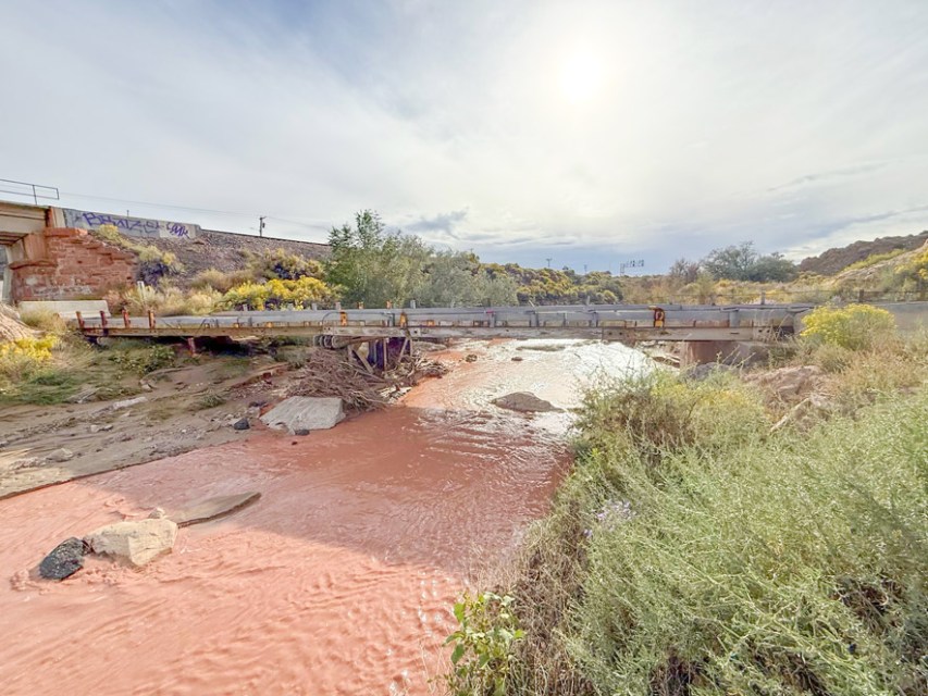
Red-tinted water flows down the Puerco River beneath a bridge Sunday, Sept. 27, in Gallup.

GALLUP
Less than two weeks after floodwaters took the lives of three people in the Two Grey Hills area, another round of heavy rain is threatening the Navajo Nation. Local officials are warning residents that roads and washes already damaged by September storms could turn dangerous again.
Council Delegate Andy Nez was asked by text message how many roads might have been damaged by the last monsoon rains.
“I am not aware of any closures or impassable routes, but there were a few reported,” he wrote. “I don’t know how many overall, but those I’m aware of is at least 3, but one was residential and the other two were more so higher traffic routes.”
The flooding turned deadly Sept. 16. Two adults and a juvenile drowned after being swept away near Newcomb, New Mexico, while the Navajo Nation was under a nationwide state of emergency. The Shiprock Police District responded around 12:30 a.m. to a report of people swept away in the Two Grey Hills area. Bernadine Beyale, the founder and executive director of 4 Corners K9 Search and Rescue, said all three victims were members of the same family.
Gallup Fire Chief Jon Pairett said residents should prepare alternate travel routes, keep emergency supplies ready and stay out of flooded roads and waterways.
“The biggest thing is just to plan ahead,” Pairett said.
The storm is driven by tropical moisture from hurricanes Odalys and Polo, which is combining with a low-pressure system moving inland from the West Coast. Repeated downpours could cause flash flooding on ground already saturated by recent storms.
The National Weather Service issued a flood watch for northern and central Arizona from Sunday evening, Sept. 27, through Tuesday evening, Sept. 29. The heaviest rain is expected Monday afternoon through Tuesday afternoon.
The watch includes Window Rock, Fort Defiance, Chinle, Ganado, Kayenta, Tuba City, Dilkon, Shonto and other Navajo communities. It also covers Hopi communities, Flagstaff, Prescott, Sedona, Payson, the Grand Canyon region and the White Mountains.
In New Mexico, a watch covers Gallup, Farmington, Grants and other communities along and west of the central mountain chain from Monday morning through early Wednesday. Watches also cover southeast Utah and southwest Colorado.
Flooding threat grows as rain returns
The weather service’s Flagstaff office raised its rain estimate and now expects 1 to 3 inches through late Tuesday, up from an earlier range of three-quarters of an inch to 2 inches. Forecasters warned of significant rises in waterways, including the Little Colorado River.
In New Mexico, forecasters expect widespread totals of 1 to 3 inches Monday through Wednesday, with isolated areas receiving 4 to 6 inches. Southerly wind gusts of 25 to 45 mph are expected Monday and Tuesday.
Much of northern Arizona is under a moderate risk of excessive rainfall Monday. New Mexico faces a slight to moderate risk Monday and Tuesday, with a smaller area of risk continuing Wednesday.
The storm follows an exceptionally wet stretch. In the two weeks ending Sept. 26, the weather service recorded 2.15 inches at Gallup Airport and 2.22 inches at Farmington Airport. A station about 9 miles northeast of Aztec measured 3.38 inches. A station near Clovis recorded 12.22 inches.
Additional rain could quickly become runoff, flooding washes, low-water crossings, burn scars, highway underpasses and low-lying areas. Unpaved roads could become muddy and impassable, while larger streams and rivers could overflow their banks.
A bridge connecting Historic Route 66 and Hassler Valley Road near Church Rock was heavily damaged by floods, prompting officials to close the road. Uprooted brush and tree limbs had piled high against the concrete pier of a steel-girder bridge. Floodwater had also carved away the earthen bank beneath and around the mouth of a large drainage culvert, leaving the pipe hanging over the scoured channel.
Downstream, beneath a railroad bridge, a large truck tire had been deposited on an eroded bank above muddy, still-running water. Freshly cut ledges of sand and silt lined the channel.
Pairett said debris in waterways can make floodwater especially dangerous.
“So that’s why we just tell people, stay out of the water,” Pairett said.
Pairett said residents should use the time before the storm to consider how flooding could affect their homes, daily travel and families. People whose access roads regularly flood should identify alternate routes or arrange to stay elsewhere before conditions deteriorate.
Officials urge residents to prepare
The Navajo Nation Division of Transportation issued preparedness guidance Sept. 19 with the Navajo Department of Emergency Management and Navajo Nation Police Department. The checklist included drinking water, nonperishable food, flashlights, a first-aid kit, prescription medications, phone chargers, blankets, extra clothing and important documents. Rural households were also advised to prepare supplies for pets and livestock.
The Gallup Fire Department is handing out sandbags while supplies last. Pairett said the department ordered about 5,000 roughly a month ago and had an estimated 600 to 700 left at the time of the interview, with more on order.
“We usually give out 10 sandbags per vehicle,” he said.
Floodwater can turn roads deadly
The division posted a flood advisory for Nazlini on Sept. 24. It reported that Route N8017 was flooding, with photos showing muddy water spreading across open land and cutting through the roadway.
“Do not attempt to drive through flooded roadways or cross moving water. Turn around and find an alternate route if you encounter water on the road,” the advisory reads.
Pairett said drivers should never cross water on a road. Floodwater can stall or move a vehicle, and its surface can hide damage underneath.
“Is the road washed out? Is the road intact?” Pairett asked.
He recalled flooding near Gallup’s El Rancho Hotel where the water became deep enough to float vehicles. Firefighters rescued the people inside, he said.
The weather service warns that 6 inches of moving water can knock a person down and about a foot of water can float a car or small SUV.
Pairett said anyone trapped in a vehicle by floodwater should call 911. If water is not entering a vehicle caught in moving water, people should stay inside rather than step into the current, he said.
Pairett also warned residents not to run generators indoors or heat a home with a gas stove because both can cause carbon monoxide poisoning. The Centers for Disease Control and Prevention advises running generators outdoors, more than 20 feet from doors, windows and vents.
Pairett cautioned against treating this storm as another routine round of monsoon rain.
“This is going to be a pretty widespread storm, and we kind of hope for the best, but we plan for the worst as well,” he added.
Get instant access to this story by purchasing one of our many e-edition subscriptions HERE at our Navajo Times Store.

 Highway 264,
 I-40, WB @ Winslow